Why would anyone want to sail around Cape Horn?

Cape Horn is a large headland by the sea, a bit like Bray Head really, perhaps a bit taller – but it’s its location at the very southern tip of South America that makes it such a special place.
This is where the mighty Pacific and Atlantic oceans meet. At 56° south, there is no land to the east or west of Cape Horn anywhere around the globe – the next nearest landmass is Antarctica, 600 miles further south across the Drake Passage.
In this stretch of turbulent ocean, storms are stronger and waves are bigger than anywhere else on Earth.

For a large part of my life I had dreamed of doing some kind of adventure sailing trip but like most people, never managed to do anything about it. So back in the mid-2000s, I stumbled upon a website that was to have a major impact on my life. No, it didn’t offer me the secret to instant wealth or spiritual enlightenment – and for those of you sniggering at the back, nor did it offer me any kind of chemical enhancement to make me a better lover.
Run by Whitbread Round the World Race veteran and renowned high latitude adventurer Skip Novak, pelagic.co.uk had just what I was looking for – sailing adventures in some of the most remote parts of the globe – little did I know then that this would be my first real step in to the world of adventure travel.
Of course one of the biggest issues with this kind of trip (apart from the cost), is time. Running my own business meant that three weeks was realistically the most I could absent myself for. So that immediately ruled out the more arduous trips on offer like the Antarctic Peninsula and South Georgia, both of which require more than a month on board – for now they will have to wait.
So that left The Beagle Channel and Cape Horn, starting and finishing in Puerto Williams on Isla Navarino on the southern shore of the Beagle Channel. 14 days on board plus a couple of days either end for travel – comfortable in three weeks.

On a beautiful autumnal day in April 2009 I’m15,000 kms away from home, flying from Punta Arenas to Puerto Williams in a DAP Twin Otter, the clouds part and I’m treated to a spectacular view of Ushuaia, the most southerly town in Argentina.
A short time later, we land at the tiny Chilean airstrip of Puerto Williams, at the bottom of the world. Puerto Williams is predominantly a naval town but was once home to the now extinct Yaghan Indian tribe – a rather smart modern museum in the town documents their history.
The settlement is extremely remote, once you leave the town, there is almost no other civilisation other than the wildlife. In the more sheltered spots, the trees are shrouded in a Nothofagus lichen, a real indicator of the purity of the air in this remote region.
Puerto Williams is the capital of Chilean Antarctica, a signpost in the town indicates just how far away from anywhere it really is. Close by is a monument featuring the actual bow of the Yelcho, the ship chartered by Sir Ernest Shackleton to rescue his stranded crew from Elephant Island on the 30th August 1916 after his epic journey with Tom Crean across the Southern Ocean in an open boat to South Georgia.
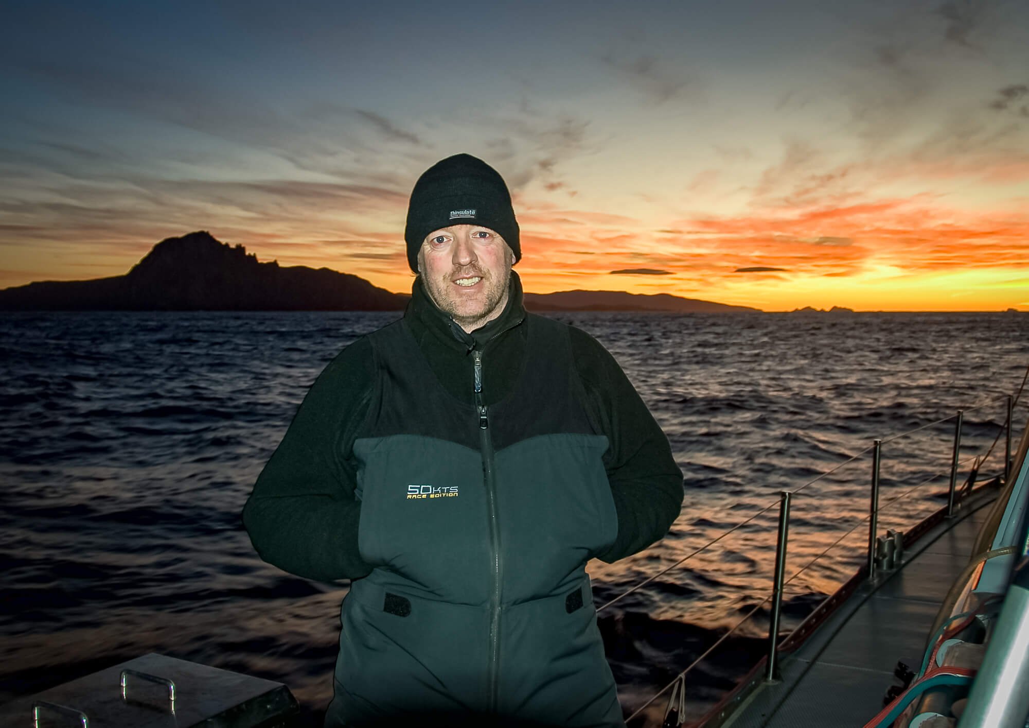
Here on the edge of the Beagle Channel I meet up with Stewart Richardson, a former skipper on one of Chay Blythe’s British Steel Challenge yachts and skipper of Pelagic Australis for the previous three seasons. We load my pack in to the RIB beached at the end of the runway and buzz out to Pelagic Australis – and what a boat! A bulletproof 75-foot cutter designed specifically for high latitude sailing – reckoned to be probably the best of her kind in the world.

The raw aluminium hull bares the scratches and scars of countless encounters with brash ice and growlers, the large doghouse with its long aft overhang protects crew from the worst of Southern Ocean weather, naturally all sail controls and reefing lines are lead aft to the spacious cockpit.
There are four huge rolling drums, each holding 250 meters of shoreline – two set in to the transom and two on deck just aft of the mast – in the calm of our anchorage in Puerto Williams this looks like complete overkill, but we will come to rely on them heavily over the next couple of weeks. There are no electric winches other than the capstan, no bow-thruster, no hydraulic furlers, no water maker, no fridge or freezer – Skip’s philosophy is to keep all systems on board as simple as possible – if something brakes on an expedition you can’t just pick up the phone and order new parts, so everything must be easy to maintain and repair – the ship needs to be entirely self-sufficient.
Pelagic Australis carries 7,500 litres of diesel so that she can survive for months at a time in the ice. Unusually for a 75 footer, she’s fitted with a lifting keel and pivoting rudder which allows her access more sheltered anchorages – in short, a huge amount of thought has gone in to this very simple boat.
The permanent crew are Stewart the skipper, first-mate Jess, Chris from the Falklands and Swiss from, yes… Switzerland. The guests are four Aussies, Mark, Louis, Andrew & Jo – two Slovakians, Robert & Peter – Santiago from Columbia – and myself.


So with all the crew aboard, supplies stowed, two lamb carcasses strapped to the aft rail (a natural fridge) and the “zarpe” (exit visa) from the Harbour Master, we set out in to the Beagle Channel and head west in to a stiff 20 knot breeze.

Our first anchorage is Caleta Ferrari at Yendegia, a wide inlet about 15 miles west of Ushuaia. Here we get weather bound for two nights as gales rip down the Beagle Channel. We go ashore and meet local “gaucho” José and his girlfriend Annalise who is from Belgium. Annalise sailed in to the bay several years earlier with some friends, fell in love with José and never left!
José needs to get some of his horses over to another ‘estancia’ about 20km away, so while the gale blows through, we offer to help. In this part of the world, horse saddles are homemade and there is only one rein instead of two – in truth, I’m really not very keen on horses and have absolutely no idea how I’m I supposed to drive one of these things! I’m much happier on a boat than a horse and have no doubt that my unfortunate mount would rather I stick to the seas. However, the scenery and wildlife are absolutely spectacular – but next time I’ll do it on foot and bring a camera!

Southern Ocean weather systems are coming through thick and fast and soon the VHF crackles in to life with a message from the Chilean Coast Guard to say The Beagle Channel is closed to small ships – this is a regular occurrence down here. The gales continue next morning so we go ashore and hike through the wind and rain up to a ridge overlooking at the magnificent Hollandia glacier. Even in the grey and flat light, the electric blue ice is incredibly vivid.
Back in 1832, the British Admiralty renamed many of the islands, channels, mountains and inlets in this region when they sent HMS Beagle under the command of Captain Robert FitzRoy to complete a survey of the area – this is the reason that English names such as Lennox, Stewart, Londonderry appear on the Admiralty charts to this day.
To keep FitzRoy company, he had brought with him the young naturalist by the name of Charles Darwin. The scientific evidence collected by Darwin on this five-year voyage, formed the basis of his theory of evolution, a process he called ‘natural selection’. His seminal book ‘The Origin of Species’ was first published in 1859, but it took many more years to eventually convince the Church that Darwin’s theory of natural selection was in fact the basic mechanism of evolution and not, as they would have the world believe, the work of a divine being. Certainly not the first time in history a blinkered religious refused to listen to fact – nor the last!
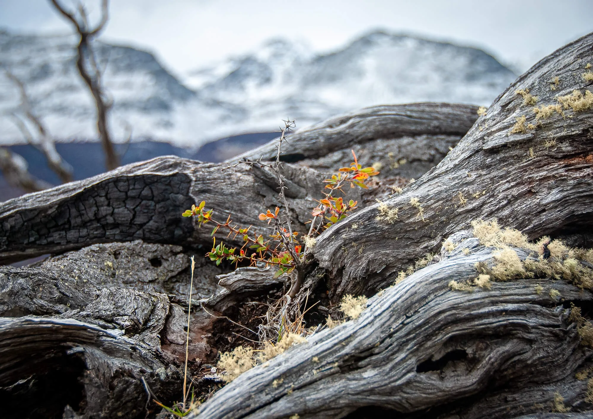
For the past couple of days, the snow line has been steadily creeping down the mountains and next morning we wake to find a fresh dusting of snow on deck. The scene is incredibly beautiful, shear rock walls tower above us but here in our protected little cove it is the safest place to be – but just in case, we’ve laid out six shore-lines to supplement the anchor, two from the bow, two from the stern and two from midships just to be sure – after all, this is ‘williwaw’ country.

Williwaws are katabatic winds that occur in high latitudes when cold, dense air gets forced up and over frozen mountain ranges by storms. Accelerated by the force of gravity, these winds can reach incredible speeds in a very short space of time as they plummet down the other side – powerful enough to rip a boat from her anchor, so up to six shore lines are used to keep the boat in place.

We take a short walk ashore in the fresh snow and enjoy spectacular views of the Romanche Glacier on the far side of the northern channel, which is only a mile wide at this point. At around midday, we collect the shore-lines, weigh anchor and set off once more for our next stop: Seno Pia.
Our arrival at the narrow mouth of the Seno Pia fjord coincides with a heavy snow shower, reducing visibility to zero. GPS maps are notoriously inaccurate around here, most of the coastline hasn’t been surveyed since FitzRoy visited nearly 180 years earlier – so, sticking to the centre of the channel, we navigate in using radar echoes from the high cliffs above – very scary in zero visibility. We spot a family of Peal’s Dolphins and once anchored they dance around in front of the RIB as we lay out the shore lines once more.

Stewart and I buzz up the fjord in the RIB to collect some ice for this evening’s gin and tonics. Stewart explains that the clearest ice comes from the centre of the glacier, over thousands of years all the air bubbles get squeezed out by the enormous weight of the glacier so that the ice is now as clear as glass – you could call it “the fillet of glacier”!

In the morning, after topping up the water tanks from a nearby waterfall, we set off up the fjord, the water is mirror calm as we cut a swathe through the brash ice. After an hour’s motoring, we round a long bend and there it is – I had seen spectacular photos of the Seno Pia glacier in National Geographic some years earlier, but nothing can prepare you for the real thing. It curves majestically between two enormous peaks, every crevasse electric blue as it twists and cascades its way steeply down to the water’s edge. It was far too dangerous to get close as large lumps of ice the size of trucks brake off every now and then – this is a very active glacier and the noise is incredible.

The scale of this monster glacier is absolutely awesome; the front wall must be 200 feet high. It’s only when you realise that the trees either side of the glacier are fully-grown conifers, that you get some idea of scale. Without doubt this is one of the real highlights of the trip.
Back out in the Beagle, the weather has settled down after the vicious winds of the previous couple of days, as we stitch our way slowly south through the Barro Merinos islands to the southern arm of the Beagle Channel – accompanied by the odd curious fur seal. Our next anchorage is Estero Coloane is a couple of miles east of Bahai Cook – this will be our last stop before the Southern Ocean and Cape Horn.
Estero Coloane has a bit of a reputation for vicious ‘williwaws’ so we lay out all six shore-lines and settle in for the night with the last of our glacier ice for our evening drink.

Over the previous couple of days there has been some considerable concern about getting an appropriate weather window to get us around Cape Horn and, given the weather patterns over the previous week, plan B – which is to return back to Puerto Williams through the Beagle – is looking increasingly possible, which would be a massive disappointment having come this far. That evening, Stewart checks the Met and there is a glimmer of hope. The depression centred above us is moving rapidly eastward and, although there will be be a nasty sting in the tail, the next system is a good way off so it looks like we will get a brief weather window in around 36 hours.
So that night we enjoy a good meal, the best Hungarian Goulash I’ve ever tasted, cooked to perfection by the Slovakians Peter & Robert and the following morning go hiking up the mountain above us as the last of the depression blows through. It’s a very steep climb in the wind and rain but well worth it for the view over the Beagle Channel and the surrounding glaciers.
But just below the summit I lose my footing in the snow and tumble about 30 feet on to some rocks. I’m a bit bruised and shook and there’s a bit of a gash in my leg but otherwise I’m fine. I think nothing of it at the time, but later back on board it occurs to me that we are in a very remote part of the world and there is no rescue immediately available. Had I been more seriously injured it could have jeopardised the entire trip for everyone else, as we would have no choice other than to head directly back to civilisation. When you consider that in these circumstances, the person standing beside you is your only safety net, it’s worth choosing your mates carefully!
The next day dawns grey and overcast again, but by the time we have cleared up and Pelagic Australis is prepared for passage, the cloud is beginning to break. At 10.00am we release her from her shackles once more and point her in the direction of Bahai Cook, gateway to the Southern Ocean.

As soon as we rounded the headland in to Cook Bay, we can feel the Southern Ocean swell. I’ve done quite a lot of sailing in my life time but this is different to any swell I have ever encountered – long and slow, easily 300 or 400 meters between crests – this is the grandfather, the patriarch of swells that has built up over thousands and thousands of miles of open ocean – today it is slow and mellow, what must it be like when angry?
So this at last is the Southern Ocean, this is what I had come all this way for and I have to say, the feeling is exhilarating! The sky is brightening all the time and bringing with it a steady 20-25 knot westerly wind, so with two reefs in the main and an almost full yankee, we turn south in the direction of Antarctica leaving the Chilean coast behind us as we head out to sea. Southern Giant Petrels and Albatross swoop and wheel above us with incredible grace and the minimum of effort.
Gradually we alter course eastward but it’s clear that at this speed we will arrive at Cape Horn too early under cover of darkness. So to slow the boat down, we put in a third reef and roll in some more headsail, with a preventer on the main and the headsail poled-out on the opposite side, we made a steady 10 knots as we goose-wing downwind. The wind slowly clocks into the northwest, pushing us deeper and deeper in to the Drake Passage close to Isla Ildefonso and even further south in the direction of the Diego Ramirez islands. At midnight, deep in the Drake Passage, we gibe and set our course for Cape Horn.
By now most people had taken to their bunks so Stewart leaves Jess and myself on watch. After about an hour, we spot a white stern light on the horizon, which is very odd because a. there is hardly any shipping in this area any more, b. no ships have passed us and c. it’s inconceivable that we would be catching up on one.
Jess picks up the VHF to try and make contact thinking that possibly it was a fishing boat but no response. Ten minutes or so later, she tries again – still nothing. After another twenty minutes there was still no answer so Jess goes below to inform Stewart – she returns a minute or so later looking rather sheepish – “he says it’s Venus rising above the horizon”!!
It’s dark – OK? We’re all a bit tired! The next watch surfaces half an hour later. Handing them cups of tea, we warn them to watch out for shipping and go below leaving them looking a bit bewildered.
I fall asleep as soon as I hit my bunk and what feels like only 5 minutes later, feel a hand on my shoulder and someone says “you’d better come and see this”. I have no idea what to expect but I still wearing my foul weather gear on so I’m on deck in less than a minute.

And there it is: Cape Horn, silhouetted against the creeping pre-dawn light and there, directly above it, as if mocking us – Venus. After all these years, I’m finally here, I don’t know if it was the cold wind, but there is definitely a tear in my eye.
There are certain times in your life that are just special even if you can’t quite explain why. In 2007, Ireland faced England in a Six Nations rugby match at GAA headquarters in Croke Park, Dublin. The last time the English national anthem had been played there was almost 100 years earlier during the Irish Revolution, when many rebel leaders had been executed on that very field by the English army firing squads. So there was something incredibly poignant about those few moments before the anthem was played – hairs on the back of the neck stuff as anyone who was there will tell you. Well this was one of those moments.
I’m really not much of a spiritual person, but there is something about this place – the countless sailors and ships that have been lost in these hostile waters down through history. How atrocious must living conditions have been for the sailors on the old square riggers, some just young boys – battling gale force head-winds for weeks on end to get around the Horn?
How did it feel to watch your only friend in the world get washed overboard in a gale, never to be seen again? And after all the mayhem, the huge relief to finally ease sheets and start heading north again to warmer climates of Valparaiso and the Spice Islands?
Today, the ghosts of a thousand sailors must have been smiling on us, the dawn could not have been more beautiful – a postcard perfect sunrise, 15 knots of breeze, it was like we’ve turned up on its day off – completely at odds with everything I had read about it.
Cape Horn itself is just a rock, but it’s the sea that surrounds it that gives it its fearsome reputation, more has been written about this stretch of water than probably anywhere else in the on Earth. The Coast Guard Station must be one of the most remote outposts in the world but is considered a very prestigious posting in the Chilean Navy.
Under normal circumstances, we’d go ashore and pay our respects to the Coast Guard and visit the monument to all the lost sailors, but this is no normal place and we know we don’t really have time to hang around, as the next weather system is hot on our heels. So we have a friendly chat on the VHF with the Coast Guard at the end of the world and reluctantly turn north through the Wollaston Islands and across Bahai Nassau.
I hadn’t slept much the previous night, so I put my head down for a couple of hours as we motor-sail across Bahai Nassau. By the time I surface, we are an hour out of Puerto Toro – our first civilisation for over two weeks.
We drop anchor and send Santiago (our only native Spanish speaker) ashore in the RIB – he manages to negotiate with some local fishermen for ‘Centolla’, native King Crab. Three bottles of Chilean red wine yield twenty crabs and for two packs of American cigarettes, they will cook them for us! We celebrate our achievement that night and eventually exhaust the ships reserves of wine, including the emergency stash from the skipper’s cabin – returning to Puerto Williams as soon as possible is now becomes imperative!
Unsurprisingly, things are a bit slow the next morning and with just 40 miles to travel back to Puerto Williams, it’s nearly midday before we weigh anchor. The northeastern end of Isla Navarino is relatively uninteresting – so apart from some fur seals and a pod of dolphins and a few ship wrecks, there really isn’t all that much to see!!
Now safely anchored again in Puerto Williams and with 4 shorelines run out, we send the RIB ashore once more for supplies (more wine). The huge weather system that’s barring down on us is only a couple of hours away and sure enough, by early evening, the first squalls hit. For the next couple of hours, the wind speed increases steadily. By 10.00pm, the Windex is reading forty knots plus, by midnight it’s well above fifty and still climbing. The noise in the rigging is spectacular to say the least.
Every skipper gets to know the noises his boat makes and at breakfast the next morning, Stewart reckons some of the gusts must have been well over sixty knots – and this is in a sheltered anchorage! It snows all day.


By evening the wind has dropped, so after dinner we pile in to the RIB to visit the Macalvi, the southernmost yacht club in the world and a Mecca for any yacht visiting Cape Horn, the Antarctic Peninsula or just cruising the Beagle Channel – and what a place!
A decommissioned coaster owned by the Chilean Navy, she sits a jaunty angle, semi-submerged on the sand at the western end of Puerto Williams harbour. During spring tides, half the bar is under water. On deck, her timbers are rotting and slippery – anywhere else in the world she would have been condemned and shut down, but here thankfully she still survives.
The furniture is an eclectic mix of old arm chairs, sofas and tables – the walls and ceiling are covered in graffiti, flags, t-shirts, knickers and even the odd bra – a living visitor’s book. The lights flicker when it rains and the toilet only flushes when the tide’s out but you won’t find a more comfortable bar anywhere in the world.
On into the night as the beers and Pisco Sours flow, the stories get taller – the wind was stronger, the weather colder, the waves bigger. We meet other globe-trekking yachties who have been exploring these waters for years; they drink their beer and smile benignly as we tell them of our adventure. But in our hearts we all know that none of us have seen anything like the extent of what Cape Horn can dish up – and hopefully never will.
What a fantastic place to finish an amazing trip and reflect on our adventure. We didn’t ‘round’ Cape Horn in the purest maritime tradition, but we visited it, saw some incredible sights, experienced some extreme weather and… we were there!
Bray Head? Eh, I don’t think so.
With thanks to: